When one thinks of hiking in Lakeside typically the beast best known as El Cajon Mountain is top of mind, but there are several trails nearby that also deserve attention. One of those is the relatively new Flume Trail in El Monte County Park . As the name suggests the Flume Trail crosses the remanants of an old flume which once brought the waters of the Cuyamaca Mountains to Grossmont Summit and farther west. With the completion and filling of nearby El Capitan Reservoir in the 1930s, the flume’s usefulness proved to be futile and so it no longer served its purpose.

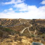
The Flume Trail isn’t for the faint of heart. This trail climbs along a steep grade through a series of switchbacks. It will get your heart pumping into overdrive, but the views along the way make the effort worthwhile.

Welcome kiosk

The trailhead for the Flume Trail begins across the street from the dirt equestrian staging area parking lot. After parking, you’ll see a large wooden kiosk and a sign that reads “Trail” with an arrow pointing you across Lake Jennings Road. Use the crosswalk to cross the street. Follow the dirt trail along a wooden fence and towards the beginning of the Flume Trail.

You’ll quickly approach another trail marker, indicating that this trail is multi-use trail accessible for equestrians. Begin the steep ascent uphill, following what seems to be an endless series of switchbacks. There are several look out points along the way that will provide you with sweeping views of Lakeside and all its farmland glory below.


Continue to follow the single-track trail for 0.6 miles. Your quads will get a welcome break here as the trail drops downhill suddenly down a short series of switchbreaks. Once you reach relative flat land and complete your descent you’ll have the option to turn right and follow the trail straight a short distance to reach a placard to read more about the old flume or you can turn left to continue hiking uphill. Either way, you’ll need to follow the trail back uphill eventually.

You’ll follow another series of steep switchbacks up the south side of the hill. This is where you’ll find the most impressive views of El Capitan to your east, a welcome reminder that much more strenuous hikes lurk nearby. At 1.5-miles, the trail descends slighly and you’ll arrive at the end of your journey, when the trail reaches Creek Hills Road.
Re-trace your steps back downhill to return back to the trailhead.

Flume Trail Tips
Tip #1: This trail is largely exposed with minimal shade coverage. It is best to hike in winter and spring months when the temperature is cooler.
Tip #2: Wear hiking boots or shoes with good traction. There are many poins on the descent that are steep while walking on loose dirt.
Tip #3: Wear long pants. There is some growth on this trail that will scrape bare legs.
Tip #4: Wear bug spray. Flies and other bugs are prevalent along the trail.
Tip #5: For free parking, park in the dirt equestrian lot about 400 feet before the El Monte County Park entrance. Parking in El Monte County Park is $3 at the time of this post.

Driving Directions
From downtown San Diego, take CA-163N and merge onto I-E toward El Centro. Drive 12.8 miles and keep right at the fork to continue on CA-67N. Drive 5.8 miles until CA-67N ends. Keep right, following signs for Mapleview Street. Turn right onto Mapleview Street. Continue onto Lake Jennings Park Road for 0.6 miles. Turn left onto El Monte Road. Park in El Monte County Park to your right after driving 4.1 miles or you can park for free in the equestrian staging area to your left after 4 miles.

Trail Difficulty: Moderate to strenuous
Total Distance: 4.4 miles
Elevation Gain: 1,200’
Trailhead Address: 15805 El Monte Rd, Lakeside, CA 92040
Dog Friendly: Yes


